User Guide
OffTrail is an offline-first navigator for adventure riders. Open the map, load a Track and ride — recordings and offline maps stay on your phone, and imported Tracks sync across your own devices only if you turn on device sync. No ads, no account.
Quick start
The map opens first. Three taps to your first ride.
- 1 · Import a Track. Open the Tracks tab and tap Import GPX to pick a
.gpxfile. It loads with its own colour. - 2 · Tap Ride. The map fills the screen with your Track on it and a live HUD on top.
- 3 · Ride. OffTrail keeps you on the line, calls your turns aloud, warns if you drift off-track, and records the whole ride automatically.
No Track yet? Open the Navigate tab and pick Round Trip for a loop of a set distance, Pick on map to route to a point, or search a place up top.

The Explore map
The map is the home screen — everything starts here.
OffTrail opens straight onto a full-screen map with your position on it. Along the top and bottom sit everything you need:
- Search bar (top) — find a place, address or coordinates without leaving the map.
- Menu (≡) — Files, Maps, Trip, Events, Groups, Sync, Settings and About.
- Three tabs — Map (just the map), Tracks (your loaded Tracks), and Navigate (every way to set off).
- Tracks tab — up to 5 loaded Tracks, each with a coloured dot; the eye shows or hides one, the ⋮ menu renames, recolours, reverses, shares or deletes it. Import GPX and Clear all Tracks live here too.
- Ride — the big accent button that starts your ride.
- Right rail — locate, basemap and zoom controls.
Loading & following Tracks
Up to five Tracks at once — kept apart.
The Tracks tab holds your loaded GPX Tracks. Tap Import GPX to add one, then Ride to follow it.
- Each Track carries its own colour so several stay legible on the map at once.
- Multi-Track files — a GPX with several Tracks stays split into sub-Tracks under one entry instead of a tangled line. Expand it to show or hide, or recolour, each one on its own; the group still counts as a single Track slot.
- The eye hides a Track without unloading it; the ⋮ menu (or a long-press) opens rename, recolour, reverse, share and delete.
- Tap a Track in the Navigate tab to be routed to its start first, then onto the line.

Navigate — choose how to ride
One tab, every way to set off.
Open the Navigate tab to pick how you want to ride:
- Route type — choose your vehicle and whether to favour trails or roads (see below).
- Home / Work — save two favourite places for one-tap routing.
- Pick on map — drop a point anywhere and route there.
- Round Trip — a circular loop of the distance you choose.
- Points of interest — route to the nearest fuel, food, water and more.
- Tracks (to the start) — pick a loaded Track to be routed to its beginning, then follow it.
Or just follow a loaded Track directly with Ride — no route needed.
Vehicle & route type
Trails or tarmac — routing built for your bike.
The Route type selector at the top of Navigate shapes every route you build:
- Off-road motorcycle — favours trails, paths and dirt for a dual-sport or enduro bike.
- Off-road 4×4 / SSV — wider tracks a vehicle can take.
- Road fun — sticks to sealed roads but prefers the twisty, scenic ones.
- Road fast — the quickest sealed route to your destination.
Off-road routes show the off-road / on-road surface split and elevation before you commit. Road types give you turn-by-turn with spoken guidance. Routing needs a connection; the maps and your Tracks work offline.
Places & POIs
Route to anywhere — several ways to pick it.
Set a destination however suits you:
- Search — type a place, address or coordinates in the bar on the map.
- Points of interest — from Navigate, find the nearest fuel, water, food, viewpoint, shop, ATM, pharmacy, hospital or mechanic.
- Pick on map — drop a point and route there.
- Home / Work — one tap to your saved places.
OffTrail plots the route in your chosen vehicle profile — favouring trails over tarmac off-road, or turn-by-turn on the road — and saves it under Files → Track to. Search and routing need a connection.

Round Trip
Pick a distance, get a loop.
From Navigate → Round Trip, choose a loop length — 50, 100, 150 or 200 km — and OffTrail builds a circular off-road route from where you are, back to where you started.
- See the whole loop with its surface split and elevation before you commit.
- Tap Ride to set off, or generate another for a different loop.
- Saved under Files → Track to, like any route.
Riding — the HUD
Eyes-up info while you ride.
However you start, the map fills the screen behind a clean heads-up display:
- ETA · speed · progress across the top, with the engaged Track or destination.
- Off-track banner in the middle, with a bearing and distance back to the line if you drift — plus an optional wrong-way alert.
- Right rail — locate (north / course-up), basemap (off-road / satellite), zoom + / – / •••, and controls to lock the screen clean. With the default auto-lock, the screen locks itself while you're moving — rain and glove touches can't move the map.
- Surface rail — a slim vertical line on the left shows the Track's surface segments in order (orange = off-road, navy = road) with a dot at your position, so you always know what's coming.
- Configurable cards — tap a corner card to choose its metric: speed, altitude, climb (D+) since you set off, ETA, trip, weather, compass and more.
- POI radar — during navigation a small chip shows the nearest fuel ahead with its distance; tap it to change the category.
- Recording runs automatically in the background — every ride is saved to History.
The map shows your basemap — off-road detail or satellite — once tiles have loaded online or from your offline maps.

Road navigation & voice
Serious turn-by-turn when you're on the tarmac.
Pick a Road route type and OffTrail switches into full turn-by-turn navigation:
- Spoken guidance calls each turn — junctions, exits and distances — so you can keep your eyes on the road.
- The next manoeuvre and the one after show on screen with their distances.
- Road fun seeks out the bends; Road fast takes the quickest way.
- Voice guidance can be turned off in Settings if you'd rather ride in silence.
Recording a Track
Lay down a clean, named Track as you ride.
Every ride is saved automatically to History. Beyond that, Record mode lets you capture a Track deliberately — start and stop it yourself.
- Turn on Record mode in Settings (or from Navigate), then start your ride. The HUD gains a record card with ● Rec / Pause / Stop.
- The breadcrumb draws live on the map; pause to break the line, resume to continue.
- Drop waypoints as you go — start, finish, danger, fuel and more.
- Stop to name and save it; it lands under Files, ready to share or ride again.
Files — recordings & routes
Everything you've ridden and built, on your phone.
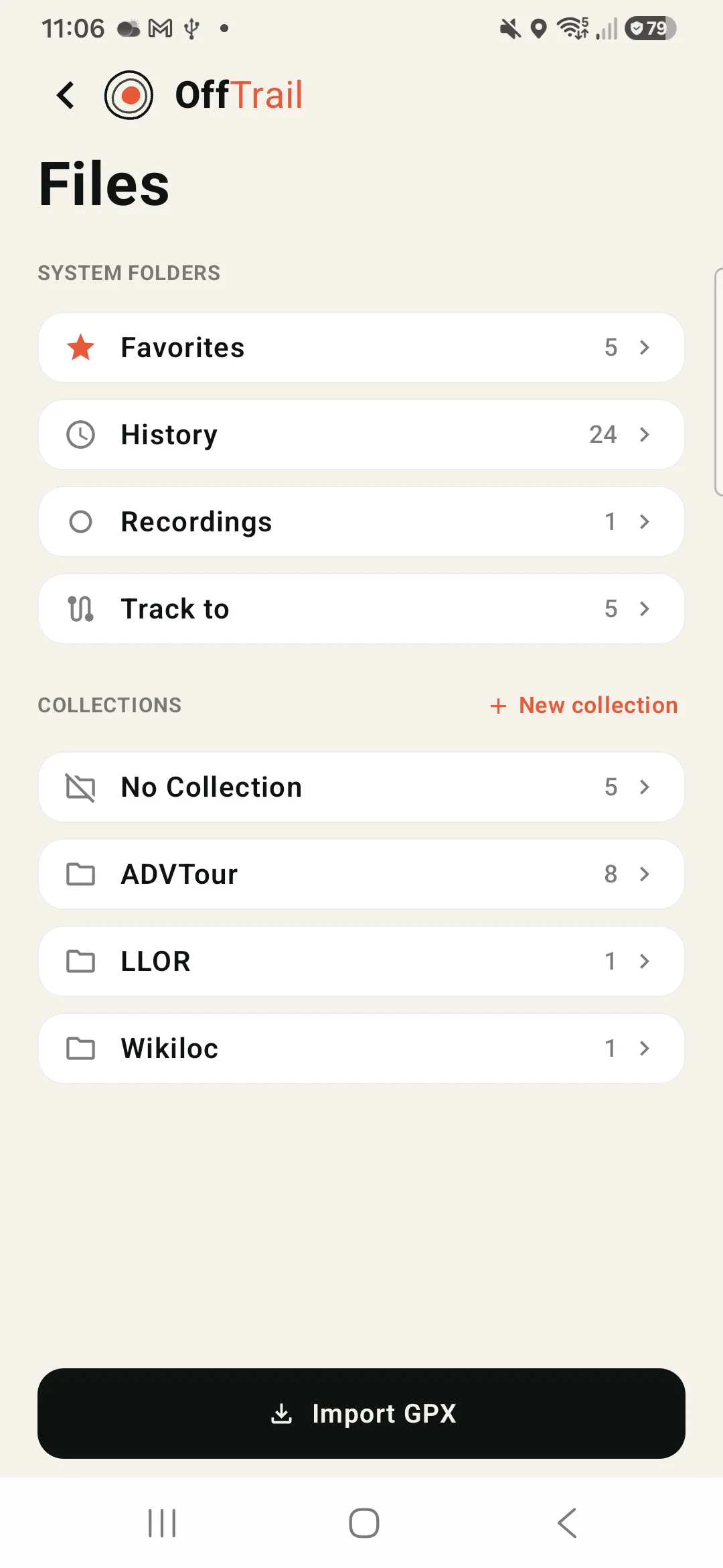
Open Files from the Menu (≡). System folders plus your own collections:
- Favorites — the Tracks on your map (the garage).
- History — the automatic recording of every ride. Rides under 100 m are discarded.
- Recordings — Tracks you captured deliberately with Record mode, waypoints and all.
- Track to — the routes and loops you generated (places, Round Trip).
- Collections — folders you create to organise imports.
Rename, share the GPX, preview, or load one back onto the map. All stored locally.
- Join — select several rides and merge them into one Track (History and Recordings). The result keeps the oldest ride's name and date, with the elevation stats recalculated.
- Delete many — the same selection mode deletes several at once, in all three lists.
- Previewing any entry opens the same full map preview as the garage — elevation, surface split and a share button next to Ride.
Share your adventure
One tap turns any ride into a card worth posting.
From a Track preview, a ride in Files, or the garage menu, tap Share and OffTrail builds a story-ready card:
- Your line over a satellite map, with distance, duration and climb (D+).
- The three surface percentages — off-road, road and unknown — just like the preview.
- A vehicle badge (moto or 4×4) you can change or remove before sharing.
- A stamp that tells the story: "Let's Go!" on a plan you're about to ride, "Done!" on a ride you've finished.
- Rename the title, then share to any app — the card is a plain image.

Sync across devices
Your Tracks on two devices — no account.
Open Sync from the Menu (≡) to keep your Tracks in step across two devices — handy if you run a phone on the bars and keep another in your pocket.
- On one device tap Create a sync code; on the other, Enter a sync code. Up to two devices.
- Add or delete a Track on one and it appears — or disappears — on the other right away.
- No account — imported Tracks sync through OffTrail's protected relay; recordings, routes and settings stay local.
- Needs a connection to sync; everything still works offline on each device. Sync, not backup — it's for convenience, not recovery.

Offline maps & POIs
Download a region, ride with no signal.
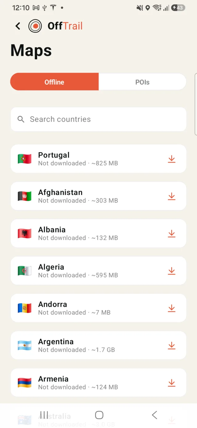
Open Maps from the Menu (≡). It has two tabs:
- Offline — search and download whole countries (each shows its size) and ride them with no signal. These are OffTrail's own dense off-road maps — the full trail, path and track network. Re-download to refresh, or delete to free space.
- POIs — choose which points of interest appear on the map: fuel, food, water, lodging, viewpoints, peaks and more.
Maps also auto-cache as you browse.
Your Track's map saves itself. When you import a GPX, OffTrail automatically caches the map around it so you can ride it with no signal. On Wi-Fi this happens silently; on cellular it asks first, with the estimated size; with no connection the card shows “map saves when you're back online” and it downloads the moment a connection returns. Choosing Always save on cellular — or turning on Downloads on cellular in Settings — auto-saves Track maps on mobile data too. Whole-country packs are much larger, so they have their own separate authorization — a switch on the Maps screen.
Trip meters (A/B)
Two resettable trip computers.
Open Trip from the Menu (≡) for two independent trip meters — Trip A and Trip B — that tot up as you ride:
- Max and average speed, distance, and total, moving and stopped time.
- Keep one for the whole trip and reset the other per day or per leg.
- Each resets on its own; a trip also resets automatically after 8 hours idle.

Group ride
Ride together, see each other live.
Open Groups from the Menu (≡). Create a group to get a code, or Enter a group code to join. Everyone shows up live on each other's maps.
- Needs Wi-Fi or cellular. Sessions are ephemeral — nothing is stored, and they end on their own after the set time.
- Set your rider name in Settings so friends recognise you.

Events
Join an organised ride with a code.
Riding an organised event that uses OffTrail? Open Events from the Menu (≡) and enter your registration code to join it.
- The event's Tracks and any live information appear in the app for the ride.
- You only need a code from the organiser — nothing to set up in advance.

CarPlay & Android Auto
The map on the car or motorcycle screen — phone in your pocket.
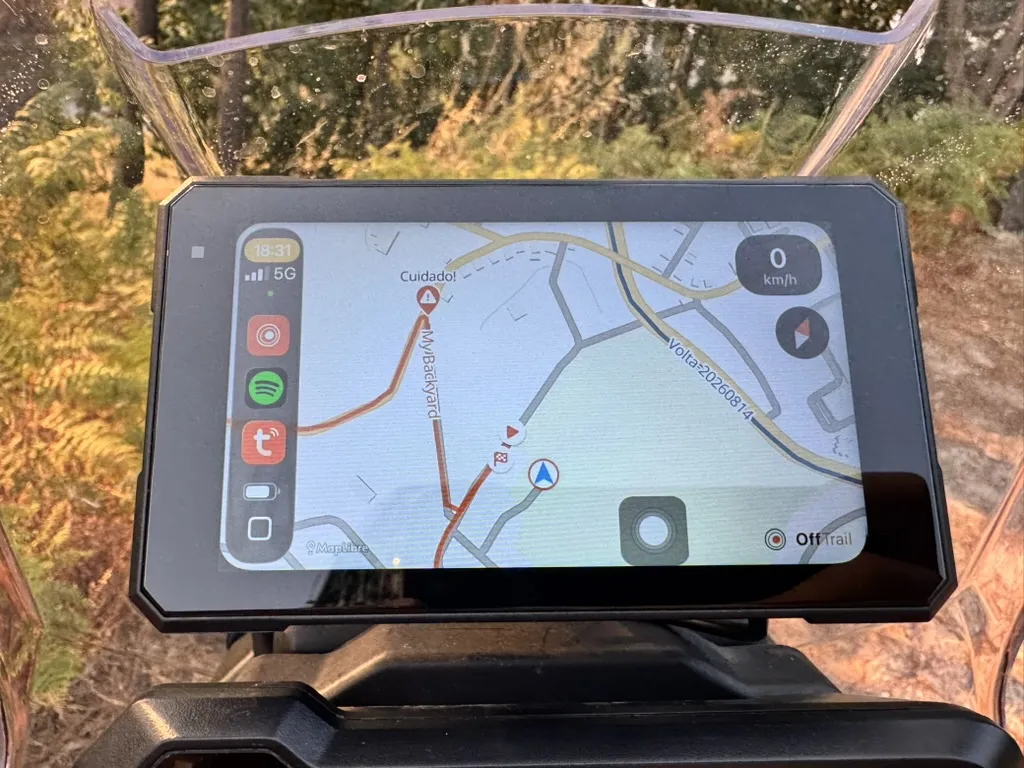
Plug into any Apple CarPlay or Android Auto screen — factory car unit or an aftermarket motorcycle display — and OffTrail appears with the live map, your garage, search and turn-by-turn guidance.
- Engage a Track from the garage (or start Ride on the phone) and the car screen follows along, with the same voice guidance.
- The surface rail runs down the right edge while a Track is engaged — the segments ahead and your position, same as the phone.
- Auto-lock screen (optional, in the car's Settings or the phone's): once you've been moving for a few seconds the screen locks against accidental touches — vibration and rain can't disturb navigation. One tap on the padlock unlocks; on Android Auto a double-tap anywhere works too. It re-locks by itself.
- The rail has voice mute, orient / recentre and zoom; Settings on the car screen holds the basemap, day / night and auto-lock.
Curious what hardware we ride with? See our field-tested displays at offtrailapp.com/devices.
Controllers
Ride with gloves on — a handlebar remote.
Pair a Bluetooth remote and map its buttons to OffTrail actions — zoom, recentre, orient, drop a waypoint, lock the screen or auto-zoom — so you can control the map without touching it. Set it up in Settings → Controllers.
- A ready-made profile for the ARN Rally remote, plus a generic mode where you teach each button.
- Pair the remote in your phone's own Bluetooth settings first.
- Full details at offtrailapp.com/devices.
Settings
A few knobs; sensible defaults.
- Rider name for group ride.
- Language (English / Português / Español), appearance (light / dark / system) and units (metric / imperial).
- Record mode, screen rotation, the wrong-way alert sound and voice guidance.
- Auto-zoom, auto-recenter, POI radar and lock-while-moving — all on by default; each can be turned off.
- Lock screen while moving in CarPlay / Android Auto — the car-screen auto-lock (off by default).
- Controllers — Bluetooth handlebar-remote profiles — and downloads on cellular.
- Storage — how much space Tracks, recordings and maps use.

About & supporting OffTrail
Free, and built by one rider.
OffTrail is free. If it's earned a place on your bars, there's an optional tip jar in About.
About also has the website, this user guide, contact, a share button and a link to rate the app.

What's new
After an update, a short summary shows once.
When you open a new version, OffTrail shows a brief "What's new" with the headline changes and a link to the full changelog. Tap OK to dismiss — it won't show again until the next update.
See every release at offtrailapp.com/changelog.
